กรองและจัดเรียง 34 ผลลัพธ์
Advanced UAV Accessories and System Components: Building High-Performance Drone Platforms
อ่านเพิ่มเติมAdvanced UAV Accessories and System Components: Building High-Performance Drone Platforms In today's rapidly advancing drone industry, the UAV itself is only the starting point. True performance, reliability, and mission capability...
The Ultimate Guide to UAV Drones and Components: High-Performance Solutions from UAVMODEL
อ่านเพิ่มเติมThe Ultimate Guide to UAV Drones and Components: High-Performance Solutions from UAVMODEL Introduction to UAV Technology and Professional Drone Systems Unmanned Aerial Vehicles (UAVs), commonly known as drones, have rapidly...
Navigating UAV Innovations: Public Safety
อ่านเพิ่มเติมNavigating UAV Innovations: Public Safety provides a comprehensive overview of how modern UAV technologies support public safety missions such as search and rescue, disaster response, wildfire monitoring, and law enforcement...

ทะยานสูง: ผลกระทบที่เปลี่ยนเกมของโดรนในเกษตรกรรม
อ่านเพิ่มเติมภาคเกษตรกรรมกำลังก้าวเข้าสู่ยุคดิจิทัล และหัวใจของการเปลี่ยนแปลงนี้คือการใช้โดรนที่เพิ่มมากขึ้น นวัตกรรมที่บินสูงเหล่านี้ไม่ใช่แค่เครื่องมือธรรมดา แต่เป็นเครื่องมือทรงพลังที่กำลังเปลี่ยนแปลงวิธีการเพาะปลูกของเรา ในบทความนี้ เราจะเจาะลึกบทบาทหลากหลายของโดรนในการเกษตรสมัยใหม่ และวิธีที่พวกมันกำลังปลูกฝังยุคใหม่ของประสิทธิภาพและผลผลิต เกษตรกรรมความแม่นยำ: มาตรฐานใหม่ โดรนที่ติดตั้งเซ็นเซอร์ขั้นสูง ช่วยให้เกษตรกรได้รับข้อมูลเชิงลึกเกี่ยวกับพืชผลของตนอย่างละเอียดในระดับความแม่นยำที่ไม่เคยจินตนาการได้มาก่อน อธิบายว่าการใช้โดรนช่วยส่งเสริมการเกษตรแบบแม่นยำได้อย่างไร โดยการตรวจสอบสุขภาพพืช วิเคราะห์สภาพดิน และจัดการทรัพยากรอย่างมีประสิทธิภาพมากขึ้น การชลประทานและการจัดการน้ำ: น้ำคือเส้นเลือดใหญ่ของการเกษตร และโดรนกำลังกลายเป็นเครื่องมือสำคัญในการรับประกันการใช้น้ำอย่างชาญฉลาด อภิปรายบทบาทของโดรนในการทำแผนที่รูปแบบการชลประทาน การตรวจจับการรั่วไหล และการประเมินความต้องการน้ำสำหรับโซนพืชผลต่าง ๆ การตรวจสอบสุขภาพพืช: หนึ่งในข้อได้เปรียบที่สำคัญที่สุดของการใช้โดรนคือความสามารถในการประเมินสุขภาพของพืชจากมุมสูง...
Unmanned Aerial Vehicle (UAV) Technology: A Comprehensive Guide
อ่านเพิ่มเติมUnmanned Aerial Vehicle (UAV) Technology: A Comprehensive Guide Unmanned Aerial Vehicles (UAVs), commonly known as drones, represent one of the fastest growing sectors in modern aerospace technology. From hobby grade...
The Ultimate Guide to Professional UAV Drones and Components (2026 Edition)
อ่านเพิ่มเติมThe Ultimate Guide to Professional UAV Drones and Components (2026 Edition) Unmanned Aerial Vehicles (UAVs), commonly known as drones, are transforming industries worldwide. From aerial mapping to precision agriculture, modern...
The Complete Guide to UAV Technology and Modern Drone Systems
อ่านเพิ่มเติมThe Complete Guide to UAV Technology and Modern Drone Systems An Unmanned Aerial Vehicle (UAV), commonly known as a drone, is an aircraft that operates without an onboard human pilot....
Advanced UAV Technology: How Modern Drones Are Transforming Global Industries
อ่านเพิ่มเติมAdvanced UAV Technology: How Modern Drones Are Transforming Global Industries Unmanned Aerial Vehicle technology, commonly known as UAV or drone technology, has rapidly evolved into a critical tool for industrial...

Agricultural Plant‑Protection Drones: Applications & Commercial Uses
อ่านเพิ่มเติมAgricultural Plant‑Protection Drones: Applications & Commercial Uses Agricultural plant‑protection drones—also known as crop‑spraying UAVs—are revolutionizing modern farming. This article explains application areas, business use cases, benefits, and highlights top...
The Ultimate Guide to Drone Electronics: Powering Modern UAV Performance
อ่านเพิ่มเติมThe Ultimate Guide to Drone Electronics: Powering Modern UAV Performance Unmanned Aerial Vehicles (UAVs), commonly known as drones, are transforming industries such as agriculture, mapping, infrastructure inspection, logistics, and security....

แผนที่โดรน: เปิดเผยความสามารถของพวกมัน
อ่านเพิ่มเติมโดรนสำรวจแผนที่ได้ปฏิวัติวงการสำรวจและการทำแผนที่อย่างมาก โดรนไร้คนขับเหล่านี้ติดตั้งเทคโนโลยีขั้นสูงที่ช่วยให้สามารถเก็บข้อมูลที่ละเอียดและแม่นยำของพื้นผิวโลกได้ ในบทความนี้ เราจะสำรวจฟังก์ชันและความสามารถต่าง ๆ ของโดรนสำรวจแผนที่

Mooring cleaning UAV syetem SF-90X-130
อ่านเพิ่มเติมIntroduction: The SF-90X-130 Mooring Cleaning UAV System In recent years, the use of unmanned aerial vehicles (UAVs) has revolutionized many industries, with maritime applications being no exception. One such innovative...
Comprehensive Guide to UAV Technology: Applications, Innovations and Industry Trends
อ่านเพิ่มเติมComprehensive Guide to UAV Technology: Applications, Innovations and Industry Trends UAV technology, short for Unmanned Aerial Vehicle technology, refers to advanced aerial systems that operate without an onboard pilot. These...
In-Depth Analysis of Drone Technology: From Hardware to Software
อ่านเพิ่มเติมExplore the latest developments in drone technology, from hardware components like flight control systems, sensors, and power systems, to the software that powers flight control, mission planning, and data processing.
The Evolution of UAV Technology: Components, Applications, and Future Trends
อ่านเพิ่มเติมThe Evolution of UAV Technology: Components, Applications, and Future Trends Unmanned Aerial Vehicles (UAVs), commonly known as drones, have transformed modern aviation and many global industries. From aerial photography and...
The Ultimate Guide to UAV Drones: Technology, Components, and Industrial Applications
อ่านเพิ่มเติมThe Ultimate Guide to UAV Drones: Technology, Components, and Industrial Applications Introduction Unmanned Aerial Vehicles (UAVs), commonly called drones, have transformed modern technology and industry. Over the past decade, UAV...
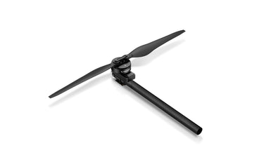
![Multi Rotor Drone Power Kit - Hobbywing X9Plus for Heavy-Lift UAVs]()
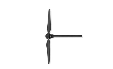
![Multi Rotor Drone Power Kit - Hobbywing X9Plus for Heavy-Lift UAVs]()
![Multi Rotor Drone Power Kit - Hobbywing X9Plus for Heavy-Lift UAVs]()

ดูอย่างรวดเร็ว 
MFD Mini Halo 1600 Mini Crosswind Fixed-Wing Drone
อ่านเพิ่มเติมMFD Mini Halo 1600 Mini Crosswind Fixed-Wing Drone: The Ultimate UAV for Precision and Efficiency In the world of unmanned aerial vehicles (UAVs), the MFD Mini Halo 1600 Mini Crosswind...

How UAV Fixed Wing Drones Are Transforming Land Surveying and GIS Mapping?
อ่านเพิ่มเติมLarge or linear projects, think highways, rail corridors, transmission lines, pipelines, coastal zones, demand faster coverage and consistent accuracy across big distances. A fixed wing UAV answers that need by...

การเพิ่มประสิทธิภาพการสำรวจธรณีฟิสิกส์ผ่านการสำรวจแผ่นดินไหวด้วยเทคโนโลยีโดรนขั้นสูง
อ่านเพิ่มเติมการวิเคราะห์เชิงลึกและข้อมูลเชิงเทคนิคเกี่ยวกับวิธีการสำรวจแผ่นดินไหวและการประยุกต์ใช้งาน
The Ultimate Guide to G35-M30 Tethered Power Station for DJI Matrice 30 Series: Revolutionizing Continuous UAV Operations
อ่านเพิ่มเติมThe Ultimate Guide to G35-M30 Tethered Power Station for DJI Matrice 30 Series: Revolutionizing Continuous UAV Operations In the rapidly evolving landscape of unmanned aerial vehicles (UAVs), operational endurance remains...

การทำแผนที่ด้วยยานพาหนะไร้คนขับ: การใช้งานและข้อดี
อ่านเพิ่มเติมการทำแผนที่ด้วยโดรน UAV ถูกนำมาใช้ในรูปแบบใดบ้าง? จำนวนไซต์ก่อสร้างที่หันมาใช้การทำแผนที่ด้วยโดรนเพื่อเพิ่มความเร็ว คุณภาพ และประสิทธิภาพกำลังเพิ่มขึ้นอย่างต่อเนื่อง ตามรายงานโดยอัลไลด์ มาร์เก็ต รีเสิร์ชอุตสาหกรรมโดรนก่อสร้างคาดว่าจะมีมูลค่าใกล้เคียง 12 พันล้านดอลลาร์ภายในปี 2027 แม้จะมีการเติบโต แต่การทำแผนที่ด้วยโดรนยังคงเป็นเครื่องมือที่ค่อนข้างใหม่สำหรับผู้รับเหมาและผู้สำรวจหลายราย ซึ่งเรียกอีกอย่างว่าการสำรวจทางอากาศ การทำแผนที่ด้วยโดรนหมายถึงการถ่ายภาพจากมุมสูงและใช้ซอฟต์แวร์เฉพาะทางในการต่อภาพเหล่านั้นเข้าด้วยกันเป็นภาพสามมิติของสถานที่ทำงาน ถ้าคุณไม่แน่ใจว่าจะทำอย่างไรUAVฟังก์ชันการทำแผนที่ด้วยโดรนหรือข้อได้เปรียบที่โดรนมอบให้นั้น ไม่ต้องกังวล—เราจะสรุปการใช้งานและอธิบายว่าโดรนสามารถช่วยคุณในการทำแผนที่และวัดพื้นที่ไซต์งานของคุณได้อย่างไร การทำแผนที่ด้วยโดรนคืออะไร? ก่อนที่จะสำรวจการใช้งานต่าง ๆ ของการทำแผนที่ด้วยโดรน สิ่งสำคัญคือต้องเริ่มต้นด้วยภาพรวมพื้นฐานของกระบวนการ: โฟโตแกรมเมตรี โฟโตแกรมเมตรีเป็นศาสตร์ในการสกัดข้อมูลทางกายภาพจากภาพสองมิติ โดยมักเป็นภาพถ่ายทางอากาศที่ถ่ายโดยโดรน โดยการรวมภาพที่ซ้อนทับกันและมีการติดแท็กตำแหน่งทางภูมิศาสตร์ของคุณลักษณะเดียวกันจากมุมมองที่แตกต่างกัน ซอฟต์แวร์โฟโตแกรมเมทรีจะสร้างแบบจำลอง 3 มิติที่เหมือนจริงของพื้นผิวภูมิประเทศ...

เหนือกว่าและก้าวล้ำ: บทบาทเปลี่ยนเกมของโดรนในการค้นหาและกู้ภัย
อ่านเพิ่มเติมในด้านปฏิบัติการค้นหาและกู้ภัย ทุกวินาทีมีความสำคัญ เทคโนโลยีโดรนได้สร้างการเปลี่ยนแปลงครั้งใหญ่ในวิธีการดำเนินภารกิจที่สำคัญเหล่านี้ ด้วยการส่งมอบอย่างรวดเร็ว ภาพสด และการเข้าถึงพื้นที่ที่ยากลำบาก โดรนจึงกลายเป็นทรัพยากรที่มีคุณค่าในการช่วยชีวิต ข้อดีของโดรนในการค้นหาและกู้ภัย: ความเร็วและประสิทธิภาพ: โดรนสามารถถูกส่งไปใช้งานได้อย่างรวดเร็ว เข้าถึงพื้นที่ห่างไกลหรือพื้นที่ที่เข้าถึงยากได้เร็วกว่าทีมภาคพื้นดินหรือเครื่องบินแบบดั้งเดิม ภาพคุณภาพสูง: ติดตั้งกล้องความละเอียดสูงและกล้องถ่ายภาพความร้อน โดรนมอบมุมมองทางอากาศที่ละเอียดซึ่งช่วยในการค้นหาบุคคลที่สูญหายหรือประเมินสถานการณ์ภัยพิบัติได้ ความปลอดภัย: โดรนสามารถเข้าสู่สภาพแวดล้อมที่ไม่มั่นคงหรือเป็นอันตราย ช่วยลดความเสี่ยงต่อทีมกู้ภัยมนุษย์ การใช้งานในชีวิตจริง: ภัยพิบัติทางธรรมชาติ: หลังจากเกิดแผ่นดินไหว น้ำท่วม หรือพายุเฮอริเคน โดรนจะถูกใช้ในการสำรวจพื้นที่ที่ได้รับผลกระทบ ระบุบุคคลที่ติดอยู่ และประเมินความเสียหายของโครงสร้าง การกู้ภัยบนภูเขา: โดรนสามารถบินผ่านภูมิประเทศที่ขรุขระเพื่อค้นหานักเดินป่าหรือนักปีนเขาที่พลัดหลง โดยมักจะส่งมอบอุปกรณ์ช่วยชีวิตหรือชี้นำทีมกู้ภัยไปยังตำแหน่งที่แม่นยำ...

อากาศยานไร้คนขับ (UAVs): ประเภท การจำแนก และคุณสมบัติสำคัญที่อธิบาย
อ่านเพิ่มเติมหัวข้อนี้สำรวจวิธีการต่าง ๆ ที่ใช้ในการจัดประเภท UAV เช่น ตามระยะทาง ขนาด น้ำหนัก ความเป็นอิสระ ความสูง และแหล่งพลังงาน H1: ศัพท์เฉพาะ ยานบินไร้คนขับ (UAV) หรือระบบอากาศยานไร้คนขับ (UAS) ซึ่งมักเรียกกันทั่วไปว่า โดรน คืออากาศยานที่ไม่มีนักบิน ลูกเรือ หรือผู้โดยสารบนเครื่อง คำว่า "โดรน" ถูกใช้มาตั้งแต่ยุคแรกของการบิน คำว่า UAV มักใช้ในกรณีการใช้งานทางทหาร คำที่คล้ายกันคือ ยานบินที่ควบคุมจากระยะไกล...