กรองและจัดเรียง 95 ผลลัพธ์
![Makeflyeasy UAVMakeflyeasy UAV aerial survey PIXHAWK camera shutter cableUAVMODEL]()

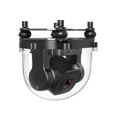
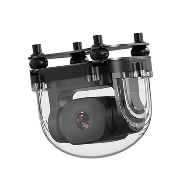
ดูอย่างรวดเร็ว ![SIYI A2 mini FPV gimbal with 1080p Starlight camera and 160-degree ultra wide angle lens]()
![SIYI A2 mini Ultra Wide Angle FPV Gimbal with 160 Degree FOV and 1080p Starlight Camera]()
![SIYI A2 mini FPV gimbal with 1080p starlight camera and 160-degree ultra wide angle lens]()

ดูอย่างรวดเร็ว 
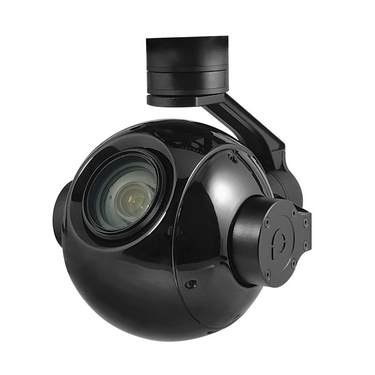
D2400W กล้อง 5 ตัว
อ่านเพิ่มเติมกล้องห้าชุดเลนส์ D2400W มีลักษณะเด่นที่น้ำหนักเบา ความแม่นยำ ความชาญฉลาด และใช้งานง่าย เป็นผลิตภัณฑ์ที่ได้รับสิทธิบัตรระดับประเทศ (หมายเลขสิทธิบัตร: 201921255998.3) D2400W พัฒนาขึ้นบนพื้นฐานของระบบนิเวศ SDK ของอากาศยานไร้คนขับ DJI และประสานงานกับอินเทอร์เฟซ DJI SKYPORT สามารถติดตั้งบนอากาศยานไร้คนขับอุตสาหกรรม DJI M300RTK, M210RTK และ M200 ซึ่งถูกใช้อย่างกว้างขวางในด้านการวางแผนที่ดิน การก่อสร้างในเมืองและชนบท การกู้ภัยฉุกเฉิน การบังคับใช้กฎหมายแบบบูรณาการในเมือง ความมั่นคงสาธารณะ และการป้องกันชายแดน รวมถึงสาขาอื่น...

PixSurvey A2 Aerial Survey Autopilot Kit
อ่านเพิ่มเติมPixSurvey A2 Aerial Survey Autopilot Kit: Revolutionizing UAV Surveying for Professionals Introduction to the PixSurvey A2 Autopilot Kit In the world of unmanned aerial systems (UAS), the need for precise,...
![Drone Camera: Pinling Q30T 30x Zoom Tracking Electro-Optical Gimbal]()
![Drone Camera: Pinling Q30T 30x Zoom Tracking Electro-Optical Gimbal]()

ดูอย่างรวดเร็ว Unmanned Aerial Vehicle (UAV) Technology: A Comprehensive Guide
อ่านเพิ่มเติมUnmanned Aerial Vehicle (UAV) Technology: A Comprehensive Guide Unmanned Aerial Vehicles (UAVs), commonly known as drones, represent one of the fastest growing sectors in modern aerospace technology. From hobby grade...
SIYI A2 Mini Ultra Wide Angle FPV Gimbal: The Ultimate 1080P Starlight Camera for Professional Drone Operations
อ่านเพิ่มเติมSIYI A2 Mini Ultra Wide Angle FPV Gimbal: The Ultimate 1080P Starlight Camera for Professional Drone Operations The rapid evolution of FPV drone technology has transformed industries ranging from aerial...

AirBrain A3PRO — Dedicated Flight Control System for Aerial Survey & AOPA Training
อ่านเพิ่มเติมAirBrain A3PRO — Dedicated Flight Control System for Aerial Survey & AOPA Training Professional flight controller for aerial survey, photogrammetry, and pilot training — industrial grade, multi-sensor redundancy, cross-wrap flight...

การทำแผนที่ด้วยยานพาหนะไร้คนขับ: การใช้งานและข้อดี
อ่านเพิ่มเติมการทำแผนที่ด้วยโดรน UAV ถูกนำมาใช้ในรูปแบบใดบ้าง? จำนวนไซต์ก่อสร้างที่หันมาใช้การทำแผนที่ด้วยโดรนเพื่อเพิ่มความเร็ว คุณภาพ และประสิทธิภาพกำลังเพิ่มขึ้นอย่างต่อเนื่อง ตามรายงานโดยอัลไลด์ มาร์เก็ต รีเสิร์ชอุตสาหกรรมโดรนก่อสร้างคาดว่าจะมีมูลค่าใกล้เคียง 12 พันล้านดอลลาร์ภายในปี 2027 แม้จะมีการเติบโต แต่การทำแผนที่ด้วยโดรนยังคงเป็นเครื่องมือที่ค่อนข้างใหม่สำหรับผู้รับเหมาและผู้สำรวจหลายราย ซึ่งเรียกอีกอย่างว่าการสำรวจทางอากาศ การทำแผนที่ด้วยโดรนหมายถึงการถ่ายภาพจากมุมสูงและใช้ซอฟต์แวร์เฉพาะทางในการต่อภาพเหล่านั้นเข้าด้วยกันเป็นภาพสามมิติของสถานที่ทำงาน ถ้าคุณไม่แน่ใจว่าจะทำอย่างไรUAVฟังก์ชันการทำแผนที่ด้วยโดรนหรือข้อได้เปรียบที่โดรนมอบให้นั้น ไม่ต้องกังวล—เราจะสรุปการใช้งานและอธิบายว่าโดรนสามารถช่วยคุณในการทำแผนที่และวัดพื้นที่ไซต์งานของคุณได้อย่างไร การทำแผนที่ด้วยโดรนคืออะไร? ก่อนที่จะสำรวจการใช้งานต่าง ๆ ของการทำแผนที่ด้วยโดรน สิ่งสำคัญคือต้องเริ่มต้นด้วยภาพรวมพื้นฐานของกระบวนการ: โฟโตแกรมเมตรี โฟโตแกรมเมตรีเป็นศาสตร์ในการสกัดข้อมูลทางกายภาพจากภาพสองมิติ โดยมักเป็นภาพถ่ายทางอากาศที่ถ่ายโดยโดรน โดยการรวมภาพที่ซ้อนทับกันและมีการติดแท็กตำแหน่งทางภูมิศาสตร์ของคุณลักษณะเดียวกันจากมุมมองที่แตกต่างกัน ซอฟต์แวร์โฟโตแกรมเมทรีจะสร้างแบบจำลอง 3 มิติที่เหมือนจริงของพื้นผิวภูมิประเทศ...

Why Fixed Wing Drones Are the Best Choice for Long-Range Aerial Surveys in the USA?
อ่านเพิ่มเติมAcross industries like agriculture, mining, energy, and infrastructure, the demand for accurate and cost-effective aerial surveys is growing quickly. From massive farmlands in the Midwest to sprawling oil pipelines in...
![โดรนปีกตาย Skywalker X8 2122 มม. UAV]()
![โดรนปีกตาย Skywalker X8 2122 มม. UAV]()
![โดรนปีกตาย Skywalker X8 2122 มม. UAV]()

ดูอย่างรวดเร็ว The Ultimate Guide to UAV Applications in 2026: Transforming Industries with Drones
อ่านเพิ่มเติมThe Ultimate Guide to UAV Applications in 2026: Transforming Industries with Drones Unmanned Aerial Vehicles (UAVs), commonly known as drones, are transforming industries worldwide. From precision agriculture and infrastructure inspection...
![Yuanhang Studio X1300 Pusher-Prop FPV Fixed-Wing Carrier Aircraft]()
![Yuanhang Studio X1300 Pusher-Prop FPV Fixed-Wing Carrier Aircraft]()
![Yuanhang Studio X1300 Pusher-Prop FPV Fixed-Wing Carrier Aircraft]()

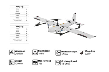
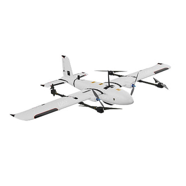
ดูอย่างรวดเร็ว ![Makeflyeasy Striver mini 4+1/4+2 2100mm UAV ปีกคงที่ VTOL โดรน]()
![Makeflyeasy Striver miniMakeflyeasy Striver mini 4+1/4+2 2100mm UAV Fixed Wing VTOL DronesUAVMODEL]()
![Makeflyeasy Striver miniMakeflyeasy Striver mini 4+1/4+2 2100mm UAV Fixed Wing VTOL DronesUAVMODEL]()

ดูอย่างรวดเร็ว The Ultimate Guide to Professional UAV Drones and Components (2026 Edition)
อ่านเพิ่มเติมThe Ultimate Guide to Professional UAV Drones and Components (2026 Edition) Unmanned Aerial Vehicles (UAVs), commonly known as drones, are transforming industries worldwide. From aerial mapping to precision agriculture, modern...
![Skywalker X8 Pro upgraded version fixed-wing drone]()
![Skywalker X8 Pro upgraded version fixed-wing drone]()
![Skywalker X8 Pro upgraded version fixed-wing drone]()

ดูอย่างรวดเร็ว ![Makeflyeasy Pioneer 3200mm UAV Fixed Wing VTOL Drones]()
![Makeflyeasy Pioneer 3200mm Fixed Wing UAV with Vertical Takeoff]()
![Makeflyeasy Pioneer 3200mm Fixed Wing UAV with Vertical Takeoff]()

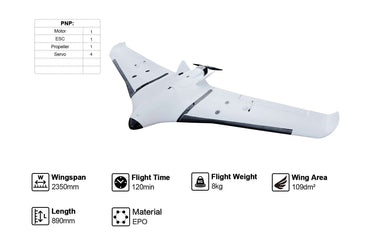
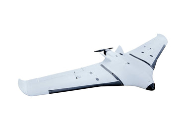
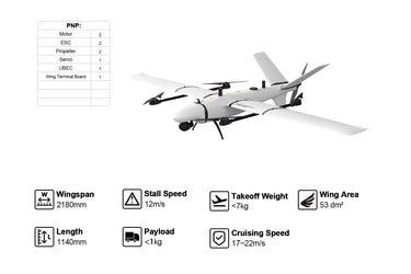
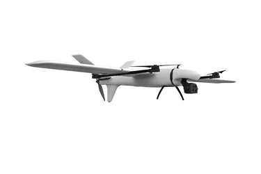
ดูอย่างรวดเร็ว ![Makeflyeasy Hero 2180mm UAV ปีกคงที่ VTOL โดรน – เวอร์ชันแผนที่ บินได้นาน 136 นาที]()
![Makeflyeasy Hero 2180mm fixed wing VTOL drone for mapping with 136 min flight time]()
![Makeflyeasy Hero 2180mm VTOL drone with fixed wing, carbon fiber body, 136 min flight time, mapping version.]()

ดูอย่างรวดเร็ว Skywalker X8 2122mm UAV Fixed Wing Drone: The Ultimate Long-Range FPV and Survey Platform
อ่านเพิ่มเติมSkywalker X8 2122mm UAV Fixed Wing Drone: The Ultimate Long-Range FPV and Survey Platform In the rapidly evolving world of unmanned aerial vehicles, fixed-wing drones continue to dominate long-range and...
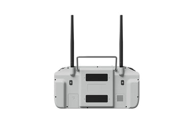
![Skydroid G20 Remote Control with Dual-Band 2.4G/5.8G GR01 Receiver for Drones]()
![Skydroid G20 Remote Control with Dual-Band 2.4G/5.8G GR01 Receiver for Drones]()

ดูอย่างรวดเร็ว Comprehensive Guide to UAV Technology: Applications, Innovations and Industry Trends
อ่านเพิ่มเติมComprehensive Guide to UAV Technology: Applications, Innovations and Industry Trends UAV technology, short for Unmanned Aerial Vehicle technology, refers to advanced aerial systems that operate without an onboard pilot. These...
The Complete Guide to UAV Technology and Modern Drone Systems
อ่านเพิ่มเติมThe Complete Guide to UAV Technology and Modern Drone Systems An Unmanned Aerial Vehicle (UAV), commonly known as a drone, is an aircraft that operates without an onboard human pilot....
The Evolution of UAV Technology: Components, Applications, and Future Trends
อ่านเพิ่มเติมThe Evolution of UAV Technology: Components, Applications, and Future Trends Unmanned Aerial Vehicles (UAVs), commonly known as drones, have transformed modern aviation and many global industries. From aerial photography and...