Filtrar y ordenar 138 resultados
![Makeflyeasy Hero MonitoringMakeflyeasy Hero Monitoring Aerial Survey Carrier Kit (small parts) AcUAVMODEL]()
![Makeflyeasy Hero MonitoringMakeflyeasy Hero Monitoring Aerial Survey Carrier Kit (small parts) AcUAVMODEL]()
![Makeflyeasy Hero MonitoringMakeflyeasy Hero Monitoring Aerial Survey Carrier Kit (small parts) AcUAVMODEL]()

Vista rápida ![Fighter Aerial SurveyFighter Aerial Survey Carrier Kit (small parts) Accessory Kit UAVUAVMODEL]()
![Fighter Aerial SurveyFighter Aerial Survey Carrier Kit (small parts) Accessory Kit UAVUAVMODEL]()
![Fighter Aerial SurveyFighter Aerial Survey Carrier Kit (small parts) Accessory Kit UAVUAVMODEL]()

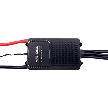
Vista rápida ![12S 100A ESC for Aerial Survey Multirotor Aircraft | Makeflyeasy]()

Vista rápida ![MakeflyeasyMakeflyeasy Aerial Survey High Efficiency Electrical Factory Custom ReUAVMODEL]()
![MakeflyeasyMakeflyeasy Aerial Survey High Efficiency Electrical Factory Custom ReUAVMODEL]()
![MakeflyeasyMakeflyeasy Aerial Survey High Efficiency Electrical Factory Custom ReUAVMODEL]()

Vista rápida ![Believer Aerial Survey Carrier Kit[MFE] Believer Aerial Survey Carrier Kit (EPO, EVA, Carbon Tube, ABS CUAVMODEL]()
![Believer Aerial Survey Carrier Kit[MFE] Believer Aerial Survey Carrier Kit (EPO, EVA, Carbon Tube, ABS CUAVMODEL]()
![Believer Aerial Survey Carrier Kit[MFE] Believer Aerial Survey Carrier Kit (EPO, EVA, Carbon Tube, ABS CUAVMODEL]()
![Believer Aerial Survey Carrier Kit[MFE] Believer Aerial Survey Carrier Kit (EPO, EVA, Carbon Tube, ABS CUAVMODEL](//www.uavmodel.com/cdn/shop/files/1_2e79ca30-9144-4132-bf81-fa7f19eff551.jpg?v=1761901798&width=20)
Vista rápida 
PixSurvey A2 Aerial Survey Autopilot Kit
Lee masPixSurvey A2 Aerial Survey Autopilot Kit: Revolutionizing UAV Surveying for Professionals Introduction to the PixSurvey A2 Autopilot Kit In the world of unmanned aerial systems (UAS), the need for precise,...

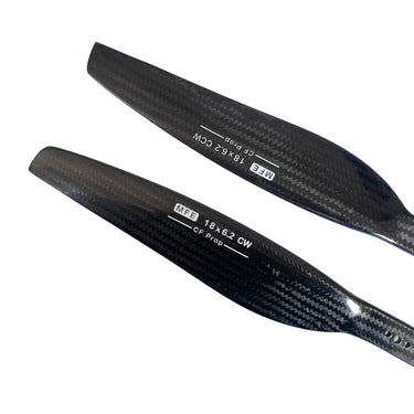
Vista rápida ![Makeflyeasy Carbon fiberMakeflyeasy Carbon fiber composite propeller 1862 dynamic balance caliUAVMODEL]()
![Makeflyeasy Carbon fiberMakeflyeasy Carbon fiber composite propeller 1862 dynamic balance caliUAVMODEL]()
![Makeflyeasy Carbon fiberMakeflyeasy Carbon fiber composite propeller 1862 dynamic balance caliUAVMODEL]()

Vista rápida ![Makeflyeasy UAVMakeflyeasy UAV aerial survey PIXHAWK camera shutter cableUAVMODEL]()

Vista rápida ![Makeflyeasy Pioneer Aerial Survey Aircraft Kit Small Parts]()
![Makeflyeasy Pioneer Aerial Survey Aircraft Kit Small Parts]()
![Makeflyeasy Pioneer Aerial Survey Aircraft Kit Small Parts]()

Vista rápida 
AirBrain A3PRO — Dedicated Flight Control System for Aerial Survey & AOPA Training
Lee masAirBrain A3PRO — Dedicated Flight Control System for Aerial Survey & AOPA Training Professional flight controller for aerial survey, photogrammetry, and pilot training — industrial grade, multi-sensor redundancy, cross-wrap flight...
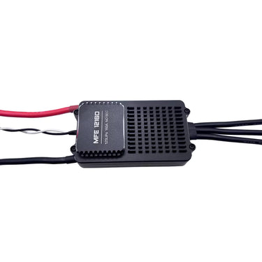
![Makeflyeasy 12S 160A ESC for aerial surveying and cruising For PIONNER only]()
![Makeflyeasy 12S 160A ESC for aerial surveying and cruising For PIONNER only]()
![Makeflyeasy 12S 160A ESC for aerial surveying and cruising For PIONNER only]()

Vista rápida Skywalker X8 2122mm UAV Fixed Wing Drone: The Ultimate Long-Range FPV and Survey Platform
Lee masSkywalker X8 2122mm UAV Fixed Wing Drone: The Ultimate Long-Range FPV and Survey Platform In the rapidly evolving world of unmanned aerial vehicles, fixed-wing drones continue to dominate long-range and...

Why Fixed Wing Drones Are the Best Choice for Long-Range Aerial Surveys in the USA?
Lee masAcross industries like agriculture, mining, energy, and infrastructure, the demand for accurate and cost-effective aerial surveys is growing quickly. From massive farmlands in the Midwest to sprawling oil pipelines in...
![Makeflyeasy Hero MonitoringMakeflyeasy Hero Monitoring Aerial Survey Carrier KIT (EPO, EVA, CarboUAVMODEL]()
![Makeflyeasy Hero MonitoringMakeflyeasy Hero Monitoring Aerial Survey Carrier KIT (EPO, EVA, CarboUAVMODEL]()
![Makeflyeasy Hero MonitoringMakeflyeasy Hero Monitoring Aerial Survey Carrier KIT (EPO, EVA, CarboUAVMODEL]()

Vista rápida Unmanned Aerial Vehicle (UAV) Technology: A Comprehensive Guide
Lee masUnmanned Aerial Vehicle (UAV) Technology: A Comprehensive Guide Unmanned Aerial Vehicles (UAVs), commonly known as drones, represent one of the fastest growing sectors in modern aerospace technology. From hobby grade...

Mapping Unmanned Aerial Vehicle: Uses and Advantages
Lee masHow is UAV drone mapping utilized? An increasing number of construction sites are turning to drone mapping to boost speed, quality, and efficiency. As reported by Allied Market Research, the...
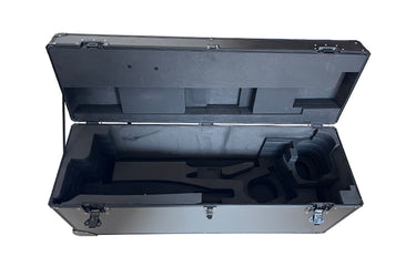
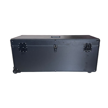
![HERO Aerial Survey DroneMakeflyeasy HERO Aerial Survey Drone Transport Case Portable Case OtheUAVMODEL]()
![HERO Aerial Survey DroneMakeflyeasy HERO Aerial Survey Drone Transport Case Portable Case OtheUAVMODEL]()
![HERO Aerial Survey DroneMakeflyeasy HERO Aerial Survey Drone Transport Case Portable Case OtheUAVMODEL]()

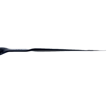
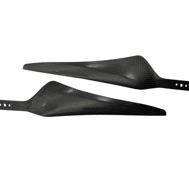
Vista rápida ![Makeflyeasy 17*55 carbon fiber propellerMakeflyeasy 17*55 1755 Carbon Fiber Propeller Aerial Survey UAV ForwarUAVMODEL]()
![Makeflyeasy 17*55 carbon fiber propellerMakeflyeasy 17*55 1755 Carbon Fiber Propeller Aerial Survey UAV ForwarUAVMODEL]()

Vista rápida ![Makeflyeasy Aerial surveyMakeflyeasy Aerial survey high-efficiency motor Customized Struggler VUAVMODEL]()

Vista rápida ![Makeflyeasy Aerial surveyMakeflyeasy Aerial survey high efficiency motor Struggler VTOL rotor mUAVMODEL]()
![Makeflyeasy Aerial surveyMakeflyeasy Aerial survey high efficiency motor Struggler VTOL rotor mUAVMODEL]()
![Makeflyeasy Aerial surveyMakeflyeasy Aerial survey high efficiency motor Struggler VTOL rotor mUAVMODEL]()

Vista rápida 
Surveying and Mapping Drones Join Hands with DeepSeek: Ushering in a New Era of Surveying and Mapping
Lee masSurveying and Mapping Drones Join Hands with DeepSeek: Ushering in a New Era of Surveying and Mapping In the era of rapid technological development today, the surveying and mapping industry...

How UAV Fixed Wing Drones Are Transforming Land Surveying and GIS Mapping?
Lee masLarge or linear projects, think highways, rail corridors, transmission lines, pipelines, coastal zones, demand faster coverage and consistent accuracy across big distances. A fixed wing UAV answers that need by...


![Believer Aerial Survey Carrier Kit[MFE] Believer Aerial Survey Carrier Kit (EPO, EVA, Carbon Tube, ABS CUAVMODEL](http://www.uavmodel.com/cdn/shop/files/2_cd469d79-3577-4867-b2d9-a84659f76a2d.jpg?v=1761901798&width=375)
![Believer Aerial Survey Carrier Kit[MFE] Believer Aerial Survey Carrier Kit (EPO, EVA, Carbon Tube, ABS CUAVMODEL](http://www.uavmodel.com/cdn/shop/files/3_3919a81b-097c-4d5a-858a-5159f0c2ce95.jpg?v=1761901797&width=375)
![Believer Aerial Survey Carrier Kit[MFE] Believer Aerial Survey Carrier Kit (EPO, EVA, Carbon Tube, ABS CUAVMODEL](http://www.uavmodel.com/cdn/shop/files/4_b8948031-e19f-476c-be58-45b9df8defb2.jpg?v=1761901797&width=375)
![Believer Aerial Survey Carrier Kit[MFE] Believer Aerial Survey Carrier Kit (EPO, EVA, Carbon Tube, ABS CUAVMODEL](http://www.uavmodel.com/cdn/shop/files/1_2e79ca30-9144-4132-bf81-fa7f19eff551.jpg?v=1761901798&width=20)