Filteren en sorteren 138 resultaten
![Makeflyeasy Hero MonitoringMakeflyeasy Hero Monitoring Aerial Survey Carrier Kit (small parts) AcUAVMODEL]()
![Makeflyeasy Hero MonitoringMakeflyeasy Hero Monitoring Aerial Survey Carrier Kit (small parts) AcUAVMODEL]()
![Makeflyeasy Hero MonitoringMakeflyeasy Hero Monitoring Aerial Survey Carrier Kit (small parts) AcUAVMODEL]()

Snelle kijk ![Fighter Aerial SurveyFighter Aerial Survey Carrier Kit (small parts) Accessory Kit UAVUAVMODEL]()
![Fighter Aerial SurveyFighter Aerial Survey Carrier Kit (small parts) Accessory Kit UAVUAVMODEL]()
![Fighter Aerial SurveyFighter Aerial Survey Carrier Kit (small parts) Accessory Kit UAVUAVMODEL]()

Snelle kijk ![12S 100A ESC for Aerial Survey Multirotor Aircraft | Makeflyeasy]()

Snelle kijk ![MakeflyeasyMakeflyeasy Aerial Survey High Efficiency Electrical Factory Custom ReUAVMODEL]()
![MakeflyeasyMakeflyeasy Aerial Survey High Efficiency Electrical Factory Custom ReUAVMODEL]()
![MakeflyeasyMakeflyeasy Aerial Survey High Efficiency Electrical Factory Custom ReUAVMODEL]()

Snelle kijk ![Believer Aerial Survey Carrier Kit[MFE] Believer Aerial Survey Carrier Kit (EPO, EVA, Carbon Tube, ABS CUAVMODEL]()
![Believer Aerial Survey Carrier Kit[MFE] Believer Aerial Survey Carrier Kit (EPO, EVA, Carbon Tube, ABS CUAVMODEL]()
![Believer Aerial Survey Carrier Kit[MFE] Believer Aerial Survey Carrier Kit (EPO, EVA, Carbon Tube, ABS CUAVMODEL]()
![Believer Aerial Survey Carrier Kit[MFE] Believer Aerial Survey Carrier Kit (EPO, EVA, Carbon Tube, ABS CUAVMODEL](//www.uavmodel.com/cdn/shop/files/1_2e79ca30-9144-4132-bf81-fa7f19eff551.jpg?v=1761901798&width=20)
Snelle kijk 
PixSurvey A2 Aerial Survey Autopilot Kit
Lees verderPixSurvey A2 Aerial Survey Autopilot Kit: Revolutionaire UAV-landmeting voor professionals Introductie van de PixSurvey A2 Autopilot Kit In de wereld van onbemande luchtvaartsystemen (UAS) is de behoefte aan precieze, betrouwbare...

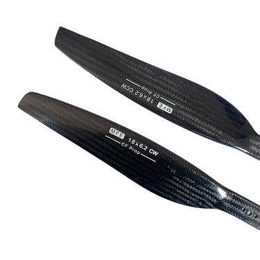
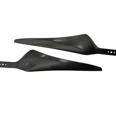
Snelle kijk ![Makeflyeasy Carbon fiberMakeflyeasy Carbon fiber composite propeller 1862 dynamic balance caliUAVMODEL]()
![Makeflyeasy Carbon fiberMakeflyeasy Carbon fiber composite propeller 1862 dynamic balance caliUAVMODEL]()
![Makeflyeasy Carbon fiberMakeflyeasy Carbon fiber composite propeller 1862 dynamic balance caliUAVMODEL]()

Snelle kijk ![Makeflyeasy UAVMakeflyeasy UAV aerial survey PIXHAWK camera shutter cableUAVMODEL]()

Snelle kijk ![Makeflyeasy Pioneer Luchtmeetvliegtuig Bouwpakket Kleine Onderdelen]()
![Makeflyeasy Pioneer Luchtmeetvliegtuig Bouwpakket Kleine Onderdelen]()
![Makeflyeasy Pioneer Luchtmeetvliegtuig Bouwpakket Kleine Onderdelen]()

Snelle kijk 
AirBrain A3PRO — Specifiek Vliegcontrolesysteem voor Luchtfotografie & AOPA Training
Lees verderAirBrain A3PRO — Specifiek Vliegcontrolesysteem voor Luchtopmetingen & AOPA Training Professionele vluchtcontroller voor luchtopmetingen, fotogrammetrie en pilotentraining — industriële kwaliteit, multi-sensor redundantie, cross-wrap vluchtondersteuning en simulatormodus. AirBrain A3PRO — compacte,...
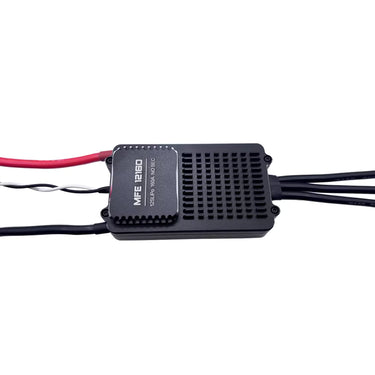
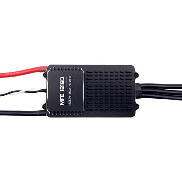
![Makeflyeasy 12S 160A ESC voor luchtinspectie en cruisen Alleen voor PIONNER]()
![Makeflyeasy 12S 160A ESC voor luchtinspectie en cruisen Alleen voor PIONNER]()
![Makeflyeasy 12S 160A ESC voor luchtinspectie en cruisen Alleen voor PIONNER]()

Snelle kijk Skywalker X8 2122 mm UAV Fixed Wing Drone: Het Ultieme Lange Afstand FPV en Survey Platform
Lees verderSkywalker X8 2122mm UAV Fixed Wing Drone: Het Ultieme Langeafstands FPV- en Surveyplatform In de snel evoluerende wereld van onbemande luchtvaartuigen blijven fixed-wing drones de missies met lange afstand en...

Waarom Fixed Wing Drones de Beste Keuze Zijn voor Langeafstandsvluchten in de VS?
Lees verderIn sectoren zoals de landbouw, mijnbouw, energie en infrastructuur groeit de vraag naar nauwkeurige en kosteneffectieve luchtfotogrammetrie snel. Van enorme landbouwgronden in het Midwesten tot uitgestrekte oliepijpleidingen in Texas: bedrijven...
![Makeflyeasy Hero MonitoringMakeflyeasy Hero Monitoring Aerial Survey Carrier KIT (EPO, EVA, CarboUAVMODEL]()
![Makeflyeasy Hero MonitoringMakeflyeasy Hero Monitoring Aerial Survey Carrier KIT (EPO, EVA, CarboUAVMODEL]()
![Makeflyeasy Hero MonitoringMakeflyeasy Hero Monitoring Aerial Survey Carrier KIT (EPO, EVA, CarboUAVMODEL]()

Snelle kijk Onbemande Luchtvaartuig (UAV) Technologie: Een Uitgebreide Gids
Lees verderOnbemande Luchtvaartuig (UAV) Technologie: Een Uitgebreide Gids Onbemande Luchtvaartuigen (UAV's), algemeen bekend als drones, vertegenwoordigen een van de snelst groeiende sectoren in de moderne luchtvaarttechnologie. Van hobby-quadcopters tot industriële VTOL-...

Mapping onbemande luchtvaartuigen: toepassingen en voordelen
Lees verderHoe wordt UAV-drone mapping gebruikt? Een toenemend aantal bouwplaatsen schakelt over op drone-mapping om snelheid, kwaliteit en efficiëntie te verbeteren. Zoals gerapporteerd doorAllied Market Research, de bouwdrone-industrie wordt naar verwachting...
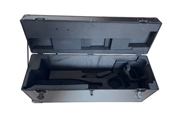
![HERO Aerial Survey DroneMakeflyeasy HERO Aerial Survey Drone Transport Case Portable Case OtheUAVMODEL]()
![HERO Aerial Survey DroneMakeflyeasy HERO Aerial Survey Drone Transport Case Portable Case OtheUAVMODEL]()
![HERO Aerial Survey DroneMakeflyeasy HERO Aerial Survey Drone Transport Case Portable Case OtheUAVMODEL]()

Snelle kijk ![Makeflyeasy 17*55 carbon fiber propellerMakeflyeasy 17*55 1755 Carbon Fiber Propeller Aerial Survey UAV ForwarUAVMODEL]()
![Makeflyeasy 17*55 carbon fiber propellerMakeflyeasy 17*55 1755 Carbon Fiber Propeller Aerial Survey UAV ForwarUAVMODEL]()

Snelle kijk ![Makeflyeasy Aerial surveyMakeflyeasy Aerial survey high-efficiency motor Customized Struggler VUAVMODEL]()

Snelle kijk ![Makeflyeasy Aerial surveyMakeflyeasy Aerial survey high efficiency motor Struggler VTOL rotor mUAVMODEL]()
![Makeflyeasy Aerial surveyMakeflyeasy Aerial survey high efficiency motor Struggler VTOL rotor mUAVMODEL]()
![Makeflyeasy Aerial surveyMakeflyeasy Aerial survey high efficiency motor Struggler VTOL rotor mUAVMODEL]()

Snelle kijk 
Landmeet- en Kaartdrone Sluit zich aan bij DeepSeek: Een Nieuwe Tijdperk van Landmeten en Kaarten
Lees verderSurveying en Mapping Drones Sluiten de Handen ineen met DeepSeek: Een Nieuwe Tijdperk van Surveying en Mapping Inluiden In het tijdperk van snelle technologische ontwikkeling vandaag de dag ondergaat de...

Hoe Fixed-Wing UAV-drones landmeetkunde en GIS-mapping transformeren?
Lees verderGrote of lineaire projecten, zoals snelwegen, spoorcorridors, hoogspanningslijnen, pijpleidingen, kustzones, vereisen snellere dekking en consistente nauwkeurigheid over grote afstanden. Een vastvleugelige UAV beantwoordt aan die behoefte door vliegtijd in te...


![Believer Aerial Survey Carrier Kit[MFE] Believer Aerial Survey Carrier Kit (EPO, EVA, Carbon Tube, ABS CUAVMODEL](http://www.uavmodel.com/cdn/shop/files/2_cd469d79-3577-4867-b2d9-a84659f76a2d.jpg?v=1761901798&width=375)
![Believer Aerial Survey Carrier Kit[MFE] Believer Aerial Survey Carrier Kit (EPO, EVA, Carbon Tube, ABS CUAVMODEL](http://www.uavmodel.com/cdn/shop/files/3_3919a81b-097c-4d5a-858a-5159f0c2ce95.jpg?v=1761901797&width=375)
![Believer Aerial Survey Carrier Kit[MFE] Believer Aerial Survey Carrier Kit (EPO, EVA, Carbon Tube, ABS CUAVMODEL](http://www.uavmodel.com/cdn/shop/files/4_b8948031-e19f-476c-be58-45b9df8defb2.jpg?v=1761901797&width=375)
![Believer Aerial Survey Carrier Kit[MFE] Believer Aerial Survey Carrier Kit (EPO, EVA, Carbon Tube, ABS CUAVMODEL](http://www.uavmodel.com/cdn/shop/files/1_2e79ca30-9144-4132-bf81-fa7f19eff551.jpg?v=1761901798&width=20)